Hiking Siyeh Pass in Glacier National Park

Siyeh Pass Hike Profile
Glacier Guides Difficulty Rating: Strenuous.
Elevation Gain: 2,240 ft./683 m (3,440 ft./1,048 m descent)
Mileage: 10.1 miles (16.3 km) round trip.
Hiking Time (estimate): Allow 3 ½ -4 hours to reach the pass, 1 hour for lunch, and 3- 3 ½ hours to complete your trip.
Other: Portions of this trail are very exposed! Proper sun, wind, and rain protection are necessary. Hiking the entirety of the Siyeh Pass trail requires the use of a shuttle to return to your car – you do not start and end at the same trailheads. Snow may impede access to the Pass through early summer.
Siyeh Pass Logistics
Trailhead: Piegan Pass (5,847 ft.). Trail ends at Sunrift Gorge, take a GNP shuttle back to Piegan Pass Trailhead.
Bathrooms: No pit toilet. The closest bathrooms are at Logan Pass.
Water: There is potable water at Logan Pass.
Parking: Park at Siyeh Bend, about 3 miles east of Logan Pass.
Travel Time: 1 hour and 20 minutes/34 miles from GNP West Entrance; 30 minutes/15 miles from East Entrance.
Siyeh Pass Has It All!
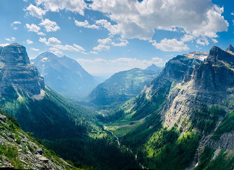
The Siyeh Pass Loop hike covers it all: alpine meadows, multiple glaciers, and impressive vistas into three separate valleys. Over the course of 10 miles, the trail transitions from old growth spruce-fir forest to high elevation scree fields. Siyeh Pass is a demanding full day adventure with a 3,500 ft. descent. Remember to bring your trekking poles!
Beginning from the Piegan Pass Trailhead, drop down to Siyeh Creek. Stromatolites line this first section of trail parallel to the creek. These fossils are 1.5 billion year old cyanobacteria that formed in an ancient shallow body of water known as the Belt Sea. After 200 yards the trail makes a sharp right turn into the forest. Notice the broken and dead trees from an avalanche that came off the east face of Piegan Mountain (9,219 ft.). After entering the stands of giant Engelmann spruce, huckleberry bushes line the trail under the canopy. In early summer there are small streams you will walk through along this section of trail. Hiking boots are recommended.
The Junction
Just over a mile from the trailhead, hikers arrive at the Piegan Pass Trail junction. Turn left towards Piegan/Siyeh Pass. A mile and a quarter later the trail crosses over Siyeh Creek. This is a good place to break and filter water. Siyeh Mountain (10,003 ft.) is prominent to the north, with Piegan Glacier to the west and Matahpi Peak (9,364 ft.) to the east. Glacier has six “Big Six” peaks that stand over 10,000 ft., including Siyeh.
The forest begins to thin as meadows become more prevalent in approaching the Siyeh Pass junction. This is located 2.7 miles from the trailhead and a half-mile from Siyeh Creek. Next, turn right here to continue to Siyeh Pass – if you go left, you will hike to Piegan Pass instead of Siyeh Pass. From this junction the trail enters Preston Park, famous for its wildflowers.
As you weave between forest and meadows, look for wildlife such as moose, elk, and bear. Siyeh Pass’s notorious switchbacks are visible rising in the distance above the treeline along the north flank of Matahpi Peak. Three quarters of a mile from the last junction, you will reach a stream crossing over Siyeh Creek. This can be a difficult crossing in early summer: use caution.
Once across the creek, the trail begins to rise out of the treeline as you approach the grueling Siyeh Pass switchbacks. The first switchback marks one mile and 740 ft. of gain until reaching the high point of the trail. On your way up admire the increasingly stunning westward views of Preston Park below and Piegan Glacier and the Continental Divide in the distance. Siyeh Pass is actually below you at this point, the saddle between Matahpi and Siyeh Mountains.
What Does Siyeh Pass Mean?
The pass and mountain was named by G. B. Grinnell for a Blackfeet Indian, “Sai-yeh,” which in Blackfeet means Crazy Dog or Mad Wolf (NPS). Upon turning the corner onto the eastern side of Matahpi there is a narrow section of trail you must cross. Luckily for those afraid of heights this cliff section, the highest point of the trail, is very brief.
Hikers now face the pristine, trailless Boulder Creek Valley of Glacier National Park. The contrast of red and green argillite is stunning. Argillite, a Precambrian rock, is the metamorphosed mudstone of the ancient Belt Sea. Although both types of argillite have the same iron content, the red color developed due to increased oxidation, signifying it was from shallow areas of the Sea. The trail soon reaches a saddle separating the Boulder Creek and Baring Creek valleys. Enjoy this gorgeous point of the trail, a great place to eat lunch and refuel before the long descent.
The Sexton Glacier
Steep switchbacks plunge down the Baring Creek valley towards the turquoise waters of St. Mary Lake. Appearing to the right are the remnants of Sexton Glacier. From 1966 to 2005, Sexton Glacier lost over 30 percent of its surface area.
The seemingly endless first set of switchbacks ends after almost 1,500 ft. of elevation loss in two miles. From here the trail continues to descend straight down the valley, entering a burn area from the Reynolds Creek Fire of 2015. Lupine, Asters, and Indian Paintbrush color the landscape.

Three and a half miles from the pass are short switchbacks leading to the banks of Baring Creek. Take a break to ice your feet in the cool, cascading water. The last section of trail enters what is known as Sunrift Gorge. Water dives into a canyon of layered argillite and quartzite rock. The final switchbacks lead abruptly to the Going-To-The-Sun Road. To the west over the Baring Creek Bridge is the Sunrift Gorge Shuttle Stop. Westbound shuttles come every 40 minutes from 7:00 a.m. to 7:00 p.m., July 1 through Labor Day weekend. All park shuttles are free and it is approximately a ten minute ride back to the Piegan Pass Trailhead.
p.s. don’t forget to book a rafting trip for the day after you hike Siyeh Pass! The very best way to get off of your tired feet but still adventure in Glacier National Park.
Information compiled by Guide Sara Edwards
Photos courtesy of Nancy Stone