Otokomi Lake, Glacier National Park, Montana

This hike explores the Rising Sun Area. Nestled in a bright red cirque known as the Rose Basin, Hiking Otokomi Lake Glacier National Park is perfect for anyone looking for something challenging and very little foot traffic. The Otokomi Lake trail provides opportunities to learn about glaciation, forest fire ecology, wildlife, park and railroad history, Blackfeet culture, and ecological challenges the park faces.
Visit Glacier’s Magical East Side
Otokomi Lake is an advanced hike of 10.4 miles round trip with an elevation gain and loss of about 1,900 feet.
In Depth Look At Otokomi Lake
Hike Profile:
Glacier Guide Difficulty Rating: Strenuous.
Elevation Gain: 1,900 ft. (579 m).
Mileage: 10.4 miles (17.7 km) round trip.
Hiking Time (estimate): Allow 4 – 4 ½ hours to reach the lake, 1 hour for lunch, and 2½ – 3 hours to return.
Other: Snow can linger on this trail. Bring proper snow travel equipment if hiking in early summer.
Otokomi Lake Logistics:
Trailhead: Next to Rising Sun Motor Inn (4,547 ft.).
Bathrooms: There are bathrooms at Rising Sun Motor Inn and a pit toilet at Otokomi Campground.
Water: There is potable water at Rising Sun Motor Inn.
Parking: In July and August, you can take the shuttle to the Rising Sun Motor Inn main parking lot, just off the Going-to-the-Sun-Road.
Travel Time: 1 hour 45 minutes/44 miles from GNP West Entrance; 10 minutes/6 miles from East Entrance.
Otokomi Lake Hike Description:
Otokomi Lake is a hidden gem of Glacier National Park. Nestled in a bright red cirque known as the Rose Basin, Otokomi Lake is perfect for anyone looking for a challenging hike with little foot traffic. The trail to Otokomi Lake advances at a steady incline following Rose Creek. The hardest part of the hike may be finding the trailhead, which is located behind the Rising Sun Motor Inn. After parking in the Rising Sun Motor Inn lot walk towards the northwest corner to find the trailhead.
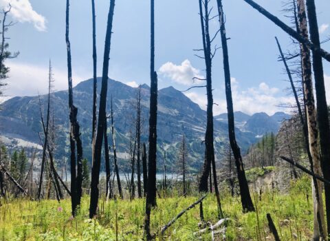
The trail, following the east bank of Rose Creek, skirts behind the Motor Inn and past numerous cabins. Built in 1940 shortly after the completion of the Going-to-the-Sun-Road, the Rising Sun Motor Inn marked the turning point of visitors touring Glacier National Park in vehicles instead of on horseback. At just under a half mile, the trail passes through the Reynolds Creek fire scar. The fire, which raged through St. Mary Valley in 2015, has been transformed into a bed of wildflowers. Many plants, including huckleberry, fireweed, and lodgepole pine, need periodic fire to thrive.
Rose Creek Falls
Two miles after entering the fire scar the trail parts from the creek and crosses a small tributary. To the left are the Rose Creek Falls, a series of gorgeous cascades. Three miles from the trailhead you will encounter a few manageable switchbacks. A half mile later the trail exits the Reynolds Fire scar for good. At this point you have reached 6,000 ft. of elevation and are only two miles from Otokomi Lake. The trail continues traversing the Rose Creek canyon through a dense Douglas Fir and Lodgepole Pine forest.
Almost five miles from the trailhead the trail transitions from forest to scree. These loose rock fragments have slowly succumbed to weathering and erosion after being formed 1.4 billion years ago. This exposed section of trail affords stunning views of surrounding glacially carved peaks and the often snow filled Rose Basin, in which sits Otokomi Lake. Just before reaching the lake the trail makes a sharp turn down to Rose Creek. At 5.5 miles is the foot of Otokomi Lake. After passing the Otokomi Campground there are a few excellent beach spots to the right. However, if you can cross Rose Creek the most dramatic views can be enjoyed from the south side of the lake.
The More You Know
One of the most exceptional features of Rose Basin is the brilliant color of the rock deposited in it. Formed in the Precambrian era, iron-rich argillite is the metamorphosed and oxidized mudstone of the ancient Belt Sea. Although both red and green colored argillite have the same iron content, the red color developed due to increased oxidation which signifies it was from shallow areas of the Sea. Otokomi Lake is reportedly named by G. B. Grinnell for Otokomi (“Yellowfish”), a Blackfeet Indian who accompanied Grinnell on his early expeditions in this region. Otokomi’s English name was Rose, so Roes Basin and Roes Creek nearby resulted from a misspelling of his name. Early topographers sometimes called the mountain surrounding the lake “Whitefish” Mountain, probably an erroneous translation of “Otokomi” which means “Yellowfish” in Blackfeet (NPS).
–Compiled by Guide Sara Edwards
–Photographs by Courtney Stone