Hiking Apikuni Falls in Glacier National Park
Hike Profile
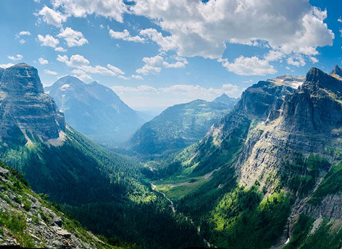
Hiking Apikuni Falls in Glacier National Park requires little effort and provides rewarding views of Many Glacier Valley. The destination is less than a mile from the trailhead. The Apikuni Falls hike transitions through meadow, forest, and finally a rocky outcropping from where the 100-foot waterfall is visible.
Not only is there a debate on how Apikuni (or Appekunny) Falls is spelled, but also of its meaning, either “white-spotted robe” or “scabby robe.” The white man who earned the Indian name of “Apikuni” married into the Blackfeet tribe and lived with them for many years. “Scabby robe” refers to one that is badly tanned with many hard spots. Though not the most flattering of names, Schultz’s memory lives on through the beautiful Apikuni Falls, Mountain, and Creek (NPS).

Logistics:
Trailhead: Apikuni Trailhead (4,918 ft).
Bathrooms: The closest bathrooms are at the Many Glacier Hotel.
Water: The closest potable water is at the Many Glacier Hotel.
Parking: The Apikuni parking area is 1.1 miles east of the Many Glacier Hotel, and has space for about 14 cars.
Travel Time: 2 hours and 15 minutes/113 miles from GNP West Entrance (via Rt. 2); 35 minutes/20 miles from East Entrance.
Apikuni Falls Hike Description:
After parking at the clearly marked Apikuni Falls trailhead sign on the Many Glacier Road (on your right), start down the trail. While walking through the meadow section look for sun-loving plants such as arrowroot, asters, and lupine. After 0.2 miles you will see a spur trail to the left; continue straight to stay on track to the falls. The trail takes you through an aspen-fir forest, gradually gaining elevation. Upon arriving at a fork in the trail 0.3 miles from the trailhead, you can choose which direction you would like to go. Both reconnect in the same trail shortly after. Choosing the right fork takes you through a forested path while the left fork is more open.
After reconnecting with the main trail, continue the gentle climb uphill. Soon the forest will make way to rocky substrate. Views of Mount Allen (9,377 ft.), Mount Siyeh (10,014 ft.), and East Flattop Mountain (8,356 ft.) command the skyline to the south. Keep following the rocky path until it peters out when the falls are in view.
Apikuni Falls flows out of Natahki Lake, which rests in a glacially carved cirque between Altyn Peak (7,947 ft.), Mount Henkel (8,770 ft.), and Apikuni Mountain (9,068 ft.). The dramatic red-green colors within the rock formed in the Precambrian era, iron-rich argillite is the metamorphosed and oxidized mudstone of the ancient Belt Sea. Although both red and green colored argillite have the same iron content, the red color developed due to increased oxidation, which signifies it was from shallow areas of the Belt Sea.
After enjoying a nice break at the falls, retrace your steps back to the Apikuni parking area.
You Won’t Know If You Don’t Go!
Be sure to check Glacier National Park’s Postings and Closures and Trail Status Reports before you head out to Apikuni Falls. This is a great early and late season hike, but do be especially careful around the falls and the creek in the spring, when the water is high. More people are injured or killed by water in Glacier than anything else — bears don’t deserve their rep!
Be prepared and have fun out there. Questions? We love helping with rafting, hiking, fishing, and biking trips in Glacier National Park. Hit us up!