Hiking Ptarmigan Tunnel in Glacier National Park
Hiking Ptarmigan Tunnel in Glacier National Park is a dance between meadow and forest. It’s the perfect butt-kicking, beautiful hike.
Glacier Guides Difficulty Rating: Strenuous.
Elevation Gain: 2,300 ft.
Mileage: 10.6 miles.
Hiking Time (estimate): Allow 4-4½ hours to reach the tunnel, 1 hour for lunch, and 3-3½ hours to return.
Other: Trails in the Many Glacier area are frequently closed due to bear activity. It is wise to check with a ranger on the status of this trail. Tunnel doors generally open mid-July to late September. Bring trekking poles and sun/wind protection.
Ptarmigan Tunnel Logistics
Trailhead: Iceberg-Ptarmigan Trailhead in Many Glacier Valley (behind Swiftcurrent Motor Inn).
Bathrooms: Swiftcurrent Motor Inn. There is one pit toilet about halfway to the tunnel (at 2.3 miles, just before Ptarmigan Falls).
Water: Fill water bottles in the Swiftcurrent Motor Inn. Filter water at Ptarmigan Falls.
Parking: There are about 15 spaces at the Iceberg-Ptarmigan Trailhead. Additional parking can be found at the Swiftcurrent Motor Inn.
Travel Time: 2 ½ hours/115 miles from GNP West Entrance via Route 2 and Duck Lake Road; 45 minutes/21 miles from the East Entrance.
Ptarmigan Tunnel Hike Description
Ptarmigan Tunnel owes its majesty to the unyielding combination of man and dynamite. The men who completed the only tunnel in Glacier National Park did not make it an easily attainable feat. Nor was the construction of the 250-foot passageway “a walk in the Park.” Two jack hammers drilling from either side of the tunnel and a series of ten-hole rounds of dynamite gradually broke through the Ptarmigan Wall after three months. Completed in September of 1930, the tunnel was originally intended for guide and tourist horses to connect with chalets throughout the park. Now that 11 of the original 12 chalet systems are no longer intact, Ptarmigan Tunnel serves to delight visitors on foot.
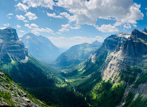
Though the hike gains considerable elevation, the grade is quite manageable to start, ending with two steep switchbacks up to the tunnel. Expect to walk through a wide variety of ecosystems, transitioning from meadows to aspen groves to spruce forest, and eventually giving way to the subalpine. Although views of Ptarmigan Lake and the Many Glacier Valley from the south side of the tunnel entrance are well worth the climb, the surprise vistas after walking through the Ptarmigan Wall are jaw-dropping, as seen above.
Let’s Get Started!
The hike to Ptarmigan Tunnel begins at the Iceberg-Ptarmigan Trailhead behind the Swiftcurrent Motor Inn. After passing the trail sign, turn right to access the short, yet steep, connector trail. The trail mellows after this quarter-mile climb. Upon reaching the Ptarmigan Trail junction, turn left, walking northwest in the opposite direction of the Many Glacier Hotel.
Continue on the Ptarmigan Trail, enjoying views of Mount Grinnell (8,851 ft.) and Swiftcurrent Mountain (8,436 ft.) towards the southwest. On clear days you can see the fire lookout on top of Swiftcurrent Peak. Westward is Mt. Wilbur (9,321 ft.), with the Ptarmigan Wall in the background. Notice the dark black band across the Ptarmigan Wall and Mount Wilbur. The diorite sill intrusion, a 100 foot thick dark band of igneous rock, formed 750 million years ago when molten rock oozed up from the earth’s mantle and spread across a weak layer of Siyeh Limestone. Heat from the intrusion recrystallized the limestone surrounding the sill into marble, known as ‘contact metamorphism.’ Looking closely at the diorite band you will notice the lighter low grade marble framing the sill.
Be Bear Aware
Prior to entering a dense lodgepole pine forest after 1.5 miles, notice the small grassy area that is littered with dig marks from bear activity on the left side of the trail. Grizzlies have 5 inch long claws and powerful shoulders designed for digging up roots such as glacier lilies. Their digging subsequently releases nitrogen to the soil, stimulating increased growth for the next year. In this area of the park you may also notice flipped rocks along the trail, likely from bears foraging for insects and their larva.
At 2.5 miles from the trailhead you will reach a small clearing that overlooks Ptarmigan Falls. Above Ptarmigan Falls is an open and rocky area that is a great for filtering water and a snack break. A pit toilet is located just before you reach these falls. After crossing the footbridge over Ptarmigan Creek you will reach the Iceberg-Ptarmigan trail junction–halfway there! Turn right to maintain course to the Ptarmigan Tunnel, which is 2.5 miles away.
Ptarmigan Lake
From this junction the trail loosely parallels Ptarmigan Creek to the turquoise waters of Ptarmigan Lake. After three miles, the spruce-fir forest becomes sparse, revealing views of the Ptarmigan Wall towering more than 1,500 feet above the trail. The transition from montane forest to subalpine rewards hikers with a burst of brightly colored wildflowers. Purple Monkeyflowers, Indian Paintbrush, and Beargrass line the trail as you approach Ptarmigan Lake.

At 4.5 miles you will reach a few spur trails to the foot of Ptarmigan Lake. The shore of this glacier tarn is an ideal spot to rest and refuel before your final push to the tunnel looming above. Look for mountain goats and bighorn sheep on the slopes. The final mile of trail to the tunnel is at at first a steady incline across argillite scree followed by two hot switchbacks. This section is very exposed, bring your sun hut! In early season snow can linger on this section of trail. Be sure to bring poles for stability and ask rangers if the trail is clear of snow before embarking on your journey.
Ptarmigan Tunnel
Upon reaching your destination, the tunnel, take a moment to enjoy the views down Many Glacier Valley. From east to west Mount Gould (9,554 ft.), Mount Grinnell, and Mount Wilber are framed by Crowfeet Mountain (8,914 ft.) and the Ptarmigan Wall. The heavy iron doors were hung across the tunnel adits during the summer of 1975. Red argillite, interbedded with layers of quartzite, lines the interior and north walls. The tunnel embodies exceptional qualities of landscape architecture and engineering artfully weaved into the natural splendor of Glacier National Park.

After reaching the north side of the tunnel, enjoy views of the Belly River Valley below. Even though this is the most northeast valley in the park, it is first to melt out after a long, cold winter. Lake Elizabeth, nestled between the mountains below, is a delight. Looking at the sheer 1,400 ft. drop below, one wonders how anyone would be brave enough to take a horse on this trail. Walk a third of a mile further for stunning views of the 10,003 ft. Mount Merritt and its Old Sun Glacier. Although this giant glacier has lost almost 20 percent of its mass between 1966 and 2015, it’s impressive nature has not subsided.
After soaking in the tremendous views from Ptarmigan Tunnel, retrace your steps to the trailhead to complete this amazing Glacier National Park hike. The trail continues on into Belly River country, but you’ll need a backcountry permit and a good tent for that adventure, as it’s longer than a day trip.